
La Niña for the next 3 or 4 months
17 Nov 2025 11:39 - 17 Nov 2025 11:44 #80082
by Serious tribe
La Niña for the next 3 or 4 months was created by Serious tribe
Hi All
So two weeks of almost contant rain and another week on the way. RNNP had 107mm over the weekend and are already 73% over the average for November. We are moving in to a La Niña cycle for the next 3 or 4 months at least, which is a mixed blessing!
I decided to run some weather data through some Ai software to get an idea of what it can do and how accurate it will prove to be and took 25 years of rainfall data for RNNP from a site I monitor and after giving it a few carefully thought out questions (at least to my mind) and follow through questions, I got the following. I did check the data, but didnt add individula months during th years etc as that would have taken to much time and I wanted to see how the ai would use the data. For the most part, it seemed accurate. This however was just a casual intetesting side escape to the editing I was doing so I wouldnt plan my potatoe crop based on it
.
1. La Niña Cycles (Expected Wet Years / Rainfall Peaks)The data strongly supports the expected wet conditions during the multi-year La Niña event that peaked in the Southern Hemisphere summer seasons of 2020/2021, 2021/2022, and 2022/2023.
Jan 2022 Peak: Rainfall was approximately 300 mm, significantly above the 185.87 mm average, making it one of the wettest Januarys on record.
Oct 2023 Extreme Peak: Rainfall was approximately 170 mm, which is the highest October rainfallin the entire 2000-2025 period and more than double the 76.14 mm average.
Dec 2023 Peak: Rainfall was approximately 220 mm, well above the 139.43 mm average
Feb 2022 Peak: Rainfall was approximately 270 mm, significantly above the 175.98 mm average.
2. El Niño Cycles (Expected Dry Years / Rainfall Troughs)The data shows a clear dry signal (trough) corresponding to the strongest El Niño event in the period, while the most recent event (2023/2024) had a more mixed effect.
Dec 2015 Extreme Trough: Rainfall was approximately 30 mm, the lowest December rainfall in the entire 2000-2024 period, confirming the severe drought conditions.
Oct 2015 Trough: Rainfall was approximately 40 mm, well below the 76.14 mm average.
Dec 2023 Mixed: Rainfall was above the monthly average (approx. 185 mm vs 139.43 mm). This suggests that other regional weather systems, such as Cut-Off Lows, can temporarily counteract the El Niño drought effect.
Jan 2024 Trough: Rainfall was below the monthly average (approx. 155 mm vs 185.87 mm).
This mixed result for 2023/2024 highlights a key point: while ENSO is the dominant driver of extreme rainfall in Southern Africa, it only explains about 30% of the overall rainfall variability, meaning local or regional factors can sometimes override the expected ENSO signal. Based on the current long-range climate models for the 2025/2026 summer and the historical data you provided for the Royal Natal National Park, the forecast is for above-average rainfall for the entire period, consistent with a La Niña phase.
I then asked it to predict what the figures would be for the next few months.
Rainfall Prediction for Royal Natal National Park (mm)The following predictions are calculated by taking the historical monthly mean (from your charts) and applying a projected increase of +25% to +40%, which is a typical range for "above-normal" rainfall during a moderate La Niña event in this region, based on the peaks observed in your 2020-2023 data.
Month Historical Average (mm/month) ENSO Forecast for PeriodPredicted Rainfall Range (mm). Expected Condition
November 2025 90.26 mm La Niña113 mm to 126 mm Above Normal
December 2025 139.43 mm La Niña174 mm to 195 mm Above Normal
January 2026 185.87 mm La Niña / Neutral transition 232 mm to 260 mm Above Normal / Peak Season
February 2026 175.98 mm La Niña / Neutral transition 220 mm to 246 mm Above Normal
Basis for the Prediction
I am certainly not a weateher expert, nor an Ai expert as related to the questions that I asked, there may have been better ways of phrasing them. The figures for RNNP for November 2025 are already at 165mm which is alreadt 73% above the average with the moderate effect at 25-40% peaking at 45-60%. So perhaps the info is not going to be accurate, but was however interesting to put together and see what will happen this cycle.
Any comments welcome.
So two weeks of almost contant rain and another week on the way. RNNP had 107mm over the weekend and are already 73% over the average for November. We are moving in to a La Niña cycle for the next 3 or 4 months at least, which is a mixed blessing!
I decided to run some weather data through some Ai software to get an idea of what it can do and how accurate it will prove to be and took 25 years of rainfall data for RNNP from a site I monitor and after giving it a few carefully thought out questions (at least to my mind) and follow through questions, I got the following. I did check the data, but didnt add individula months during th years etc as that would have taken to much time and I wanted to see how the ai would use the data. For the most part, it seemed accurate. This however was just a casual intetesting side escape to the editing I was doing so I wouldnt plan my potatoe crop based on it
This image is hidden for guests.
1. La Niña Cycles (Expected Wet Years / Rainfall Peaks)The data strongly supports the expected wet conditions during the multi-year La Niña event that peaked in the Southern Hemisphere summer seasons of 2020/2021, 2021/2022, and 2022/2023.
Jan 2022 Peak: Rainfall was approximately 300 mm, significantly above the 185.87 mm average, making it one of the wettest Januarys on record.
Oct 2023 Extreme Peak: Rainfall was approximately 170 mm, which is the highest October rainfallin the entire 2000-2025 period and more than double the 76.14 mm average.
Dec 2023 Peak: Rainfall was approximately 220 mm, well above the 139.43 mm average
Feb 2022 Peak: Rainfall was approximately 270 mm, significantly above the 175.98 mm average.
2. El Niño Cycles (Expected Dry Years / Rainfall Troughs)The data shows a clear dry signal (trough) corresponding to the strongest El Niño event in the period, while the most recent event (2023/2024) had a more mixed effect.
Dec 2015 Extreme Trough: Rainfall was approximately 30 mm, the lowest December rainfall in the entire 2000-2024 period, confirming the severe drought conditions.
Oct 2015 Trough: Rainfall was approximately 40 mm, well below the 76.14 mm average.
Dec 2023 Mixed: Rainfall was above the monthly average (approx. 185 mm vs 139.43 mm). This suggests that other regional weather systems, such as Cut-Off Lows, can temporarily counteract the El Niño drought effect.
Jan 2024 Trough: Rainfall was below the monthly average (approx. 155 mm vs 185.87 mm).
This mixed result for 2023/2024 highlights a key point: while ENSO is the dominant driver of extreme rainfall in Southern Africa, it only explains about 30% of the overall rainfall variability, meaning local or regional factors can sometimes override the expected ENSO signal. Based on the current long-range climate models for the 2025/2026 summer and the historical data you provided for the Royal Natal National Park, the forecast is for above-average rainfall for the entire period, consistent with a La Niña phase.
I then asked it to predict what the figures would be for the next few months.
Rainfall Prediction for Royal Natal National Park (mm)The following predictions are calculated by taking the historical monthly mean (from your charts) and applying a projected increase of +25% to +40%, which is a typical range for "above-normal" rainfall during a moderate La Niña event in this region, based on the peaks observed in your 2020-2023 data.
Month Historical Average (mm/month) ENSO Forecast for PeriodPredicted Rainfall Range (mm). Expected Condition
November 2025 90.26 mm La Niña113 mm to 126 mm Above Normal
December 2025 139.43 mm La Niña174 mm to 195 mm Above Normal
January 2026 185.87 mm La Niña / Neutral transition 232 mm to 260 mm Above Normal / Peak Season
February 2026 175.98 mm La Niña / Neutral transition 220 mm to 246 mm Above Normal
Basis for the Prediction
- ENSO Climate Model: International forecasts (like NOAA and IRI) indicate that La Niña conditions are present and highly favoured to persist through December 2025–February 2026, with a transition to an ENSO-Neutral phase likely starting around January–March 2026.
- Rainfall Outlook: The regional outlook for Southern Africa (including KwaZulu-Natal) is for a slight to moderate tilt in the odds favouring above-normal rainfall during this period. La Niña typically brings wetter summers to the region.
- Historical Correlation (Your Data): Your charts show that the recent La Niña events (2020-2023) produced monthly peaks that were often 45% to 65% above the long-term monthly average (e.g., December 2022 was ~58% above average). The projected range of +25% to +40% is a moderate estimate, as this La Niña is currently forecast to be relatively weak.
I am certainly not a weateher expert, nor an Ai expert as related to the questions that I asked, there may have been better ways of phrasing them. The figures for RNNP for November 2025 are already at 165mm which is alreadt 73% above the average with the moderate effect at 25-40% peaking at 45-60%. So perhaps the info is not going to be accurate, but was however interesting to put together and see what will happen this cycle.
Any comments welcome.
Last edit: 17 Nov 2025 11:44 by Serious tribe.
The following user(s) said Thank You: DeonS, firephish, GetaPix, ghaznavid, PeterHowells, MarkT, Grandeur, Riaang, riaan300, Wandelaar
Please Log in or Create an account to join the conversation.
- Serious tribe
-
 Topic Author
- Offline
- Platinum Member
-

Less
More
- Posts: 1056
- Thank you received: 770
17 Nov 2025 11:46 #80083
by ivan
Replied by ivan on topic La Niña for the next 3 or 4 months
very interesting. Thanks for sharing!
Please Log in or Create an account to join the conversation.

17 Nov 2025 14:57 #80084
by Ralph
Replied by Ralph on topic La Niña for the next 3 or 4 months
Hey ST,
Thanks for sharing, this was a very interesting read. definitely something to consider if planning a trip to the berg over the holidays.
Thanks for sharing, this was a very interesting read. definitely something to consider if planning a trip to the berg over the holidays.
Please Log in or Create an account to join the conversation.

05 Dec 2025 17:35 #80103
by Serious tribe
Replied by Serious tribe on topic La Niña for the next 3 or 4 months
So RNNP station measured 255mm for the month of November 2025. This is the highest rainfall in 25 years by 55mm, and is 167% above average for November. So it is definitely turning out to be a wet year and one wonders how much wetter it will get.
I monitor the Cath Peak web cam daily and starting most days between 9-11 the clouds roll in, it get mistly and then starts raining and stays like that for the rest of the day. The rivers must be surging!
I monitor the Cath Peak web cam daily and starting most days between 9-11 the clouds roll in, it get mistly and then starts raining and stays like that for the rest of the day. The rivers must be surging!
Please Log in or Create an account to join the conversation.
- Serious tribe
-
Topic Author
- Offline
- Platinum Member
-
Less
More
- Posts: 1056
- Thank you received: 770
09 Dec 2025 09:35 #80105
by supertramp
Replied by supertramp on topic La Niña for the next 3 or 4 months
Thanks for the update ST! Those are some serious rainfall numbers.
Starting our 12-day South to North DGT on 21 December, so holding thumbs that the weather eases up a wee bit
Starting our 12-day South to North DGT on 21 December, so holding thumbs that the weather eases up a wee bit
This image is hidden for guests.
Please Log in or Create an account to join the conversation.
- supertramp
-
- Offline
- Elite Member
-

Less
More
- Posts: 225
- Thank you received: 455
09 Dec 2025 10:14 #80106
by Smurfatefrog
Replied by Smurfatefrog on topic La Niña for the next 3 or 4 months
ah lekker, we'll see you guys on the Thomathu ridgeThanks for the update ST! Those are some serious rainfall numbers.
Starting our 12-day South to North DGT on 21 December, so holding thumbs that the weather eases up a wee bitThis image is hidden for guests.
Please Log in or Create an account to join the conversation.
- Smurfatefrog
-

- Offline
- Moderator
-

Less
More
- Posts: 1129
- Thank you received: 1542
09 Dec 2025 15:48 #80107
by ASL #Bivak
... remember to take your snorkel!
Replied by ASL #Bivak on topic La Niña for the next 3 or 4 months
This image is hidden for guests.
Please Log in or Create an account to join the conversation.
- ASL #Bivak
-

- Offline
- Platinum Member
-
Less
More
- Posts: 598
- Thank you received: 216
14 Dec 2025 19:43 #80110
by supertramp
Replied by supertramp on topic La Niña for the next 3 or 4 months
Awesome! We'll be on the lookout. Looking forward to it!ah lekker, we'll see you guys on the Thomathu ridge
This image is hidden for guests.
Please Log in or Create an account to join the conversation.
- supertramp
-
- Offline
- Elite Member
-
Less
More
- Posts: 225
- Thank you received: 455
14 Dec 2025 19:43 #80111
by supertramp
Replied by supertramp on topic La Niña for the next 3 or 4 months
Haha, and perhaps my flippers too!
... remember to take your snorkel!This image is hidden for guests.
This image is hidden for guests.
Please Log in or Create an account to join the conversation.
- supertramp
-
- Offline
- Elite Member
-
Less
More
- Posts: 225
- Thank you received: 455
27 Dec 2025 20:07 #80121
by Sterkhorn
Replied by Sterkhorn on topic La Niña for the next 3 or 4 months
Just to pick up on this topic, I thought I'd share our recent experience.
A group of 8 of us, including my 2 granddaughters (10 & 13 years), did a trip to Lower Injesuthi Cave from the 21st-23rd December.
I have done this trip on numerous occasions over the years and have always managed the river crossings without too much difficulty, including one occasion where we were advised to take the alternate route via Poacher's Stream to avoid the first major river crossing. So when we were advised by the office, and 2 hikers who had abandoned the crossing, to rather take the alternate route, I was expecting a similar result to my previous experiences. We found the two streams prior to the main Injesuthi river crossing full, but not unmanageable.
I don't know if the floods of a couple of years back have changed the layout of the Injesuthi crossings, as the last time I had to use the alternate route, we still had little difficulty in negotiating the Injesuthi crossings, but either that, or a much fuller river made our crossings this time an epic adventure.
To make matters more interesting, just before the first Injesuthi crossing, my 13 year old granddaughter slipped and suffered a buckle fracture to her wrist.
The 2 Injesuthi crossings and the stream crossing just before the cave were a real test of our energy and composure limits, but we arrived somewhat later than planned, and without any further serious incidents.
That night (21st) we had 2 major thunderstorms, which concerned me a little, but at least we had another day before returning. The next morning (22nd) we were greeted by a cave that was awash from the runoff, with a couple of the sleeping areas suffering a little from the runoff, and the whole area just past the Bushman paintings had become a large pond. I have never experienced this much water in the cave before. The drizzle of the morning cleared and I used the time to ascend the ridge above the cave. The waterfalls in the valleys towards the escarpment were impressive and the river in front of the cave was like a white snake down the valley. There was a lot of water.
The next morning (23rd) we set out with a little apprehension for what lay ahead. The crossing below the cave had now become a little treacherous and my eldest daughter had a little dunking, much to my youngest granddaughter's consternation, but we all got across safely. The first Injesuthi crossing was a lot more difficult than 2 days before, but was still manageable as at the crossing the river splits into 2, making the crossing wider.
The main crossing was a different story! Where we had crossed coming up, was now a mass of fast-flowing white water. We eventually found a more plausible diagonal crossing a little higher up, With much difficulty, mini-dunkings, inner panic, strained muscles and much team work, we all managed to cross safely. The 2 streams further along had also now become serious river crossings.
We eventually arrived back at camp at dusk after a 9 hour marathon.
It was probably one of the most difficult and taxing of hikes of my hiking experience, in terms of river crossings .
At least my granddaughters have not been put off hiking - it must "just be without rivers"
My 10 year old granddaughter being assisted across Poacher's Stream on the way up. Those rocks were under water on our return.
My 13 year old granddaughter (with arm-sling) being assisted across the Injesuthi river on day 1.
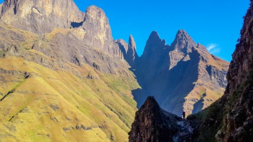
Views from the top of the ridge.
Our Injesuthi crossing on day 3.
A group of 8 of us, including my 2 granddaughters (10 & 13 years), did a trip to Lower Injesuthi Cave from the 21st-23rd December.
I have done this trip on numerous occasions over the years and have always managed the river crossings without too much difficulty, including one occasion where we were advised to take the alternate route via Poacher's Stream to avoid the first major river crossing. So when we were advised by the office, and 2 hikers who had abandoned the crossing, to rather take the alternate route, I was expecting a similar result to my previous experiences. We found the two streams prior to the main Injesuthi river crossing full, but not unmanageable.
I don't know if the floods of a couple of years back have changed the layout of the Injesuthi crossings, as the last time I had to use the alternate route, we still had little difficulty in negotiating the Injesuthi crossings, but either that, or a much fuller river made our crossings this time an epic adventure.
To make matters more interesting, just before the first Injesuthi crossing, my 13 year old granddaughter slipped and suffered a buckle fracture to her wrist.
The 2 Injesuthi crossings and the stream crossing just before the cave were a real test of our energy and composure limits, but we arrived somewhat later than planned, and without any further serious incidents.
That night (21st) we had 2 major thunderstorms, which concerned me a little, but at least we had another day before returning. The next morning (22nd) we were greeted by a cave that was awash from the runoff, with a couple of the sleeping areas suffering a little from the runoff, and the whole area just past the Bushman paintings had become a large pond. I have never experienced this much water in the cave before. The drizzle of the morning cleared and I used the time to ascend the ridge above the cave. The waterfalls in the valleys towards the escarpment were impressive and the river in front of the cave was like a white snake down the valley. There was a lot of water.
The next morning (23rd) we set out with a little apprehension for what lay ahead. The crossing below the cave had now become a little treacherous and my eldest daughter had a little dunking, much to my youngest granddaughter's consternation, but we all got across safely. The first Injesuthi crossing was a lot more difficult than 2 days before, but was still manageable as at the crossing the river splits into 2, making the crossing wider.
The main crossing was a different story! Where we had crossed coming up, was now a mass of fast-flowing white water. We eventually found a more plausible diagonal crossing a little higher up, With much difficulty, mini-dunkings, inner panic, strained muscles and much team work, we all managed to cross safely. The 2 streams further along had also now become serious river crossings.
We eventually arrived back at camp at dusk after a 9 hour marathon.
It was probably one of the most difficult and taxing of hikes of my hiking experience, in terms of river crossings .
At least my granddaughters have not been put off hiking - it must "just be without rivers"
This image is hidden for guests.
My 10 year old granddaughter being assisted across Poacher's Stream on the way up. Those rocks were under water on our return.
My 13 year old granddaughter (with arm-sling) being assisted across the Injesuthi river on day 1.
Views from the top of the ridge.
Our Injesuthi crossing on day 3.
Please login or register to view the images attached to this post.
The following user(s) said Thank You: Serious tribe, elinda, firephish, PeterHowells, Smurfatefrog, tonymarshall, grae22
Please Log in or Create an account to join the conversation.

