
Mount Durnford
20 May 2015 08:47 #63857
by Riaang
Replied by Riaang on topic Mount Durnford
Ghaz, looking at your photo from above it actually looks completely differnet from the one taken from below. The one from below looks like the low step starts right at the bottom, so thanks for the additional info. I presume the Southern side is very easy as nothing is mentioned about this side in any of the write-ups.
Boy, wishing it was time to go, all this planning makes me want to go today!")
Boy, wishing it was time to go, all this planning makes me want to go today!
Please Log in or Create an account to join the conversation.

20 May 2015 09:03 #63858
by ghaznavid
I wouldn't say easy, but there isn't a 2km+ long cliff to avoid, so navigationally it is easy. The southern side is a big steep drop down to the river in the valley. I usually stay close to the escarpment edge, tag the top of South Jarding Pass (which doesn't look like a pass from the top - there is a summit cairn though), and from the top of the pass I aim for the river. I know some people stay closer to the escarpment edge for longer - but you only save a bit of altitude and end up walking further.
Once you hit the river in the valley, just follow its gentle uphill slope (there is even a good trail in places) - eventually the river dies (there are hundred of good camping spots on this river - all within reach of the car park via Giants Pass in a day, with roughly a 3PM finish) and the small hill in front of you is the top of the Long Wall ridge. I have done that ridge N-S 3 times and S-N once - incredibly easy N-S and very steep and long S-N!
Finding Giants Pass from there is about as difficult as finding paint in an art shop - you just have to have a vague idea of what you are looking for and not end up taking the alternative gully (which is probably usable, but I am not 100% sure).
Ok - I have considerably over-answered the question
Replied by ghaznavid on topic Mount Durnford
Riaang wrote: I presume the Southern side is very easy as nothing is mentioned about this side in any of the write-ups.
I wouldn't say easy, but there isn't a 2km+ long cliff to avoid, so navigationally it is easy. The southern side is a big steep drop down to the river in the valley. I usually stay close to the escarpment edge, tag the top of South Jarding Pass (which doesn't look like a pass from the top - there is a summit cairn though), and from the top of the pass I aim for the river. I know some people stay closer to the escarpment edge for longer - but you only save a bit of altitude and end up walking further.
Once you hit the river in the valley, just follow its gentle uphill slope (there is even a good trail in places) - eventually the river dies (there are hundred of good camping spots on this river - all within reach of the car park via Giants Pass in a day, with roughly a 3PM finish) and the small hill in front of you is the top of the Long Wall ridge. I have done that ridge N-S 3 times and S-N once - incredibly easy N-S and very steep and long S-N!
Finding Giants Pass from there is about as difficult as finding paint in an art shop - you just have to have a vague idea of what you are looking for and not end up taking the alternative gully (which is probably usable, but I am not 100% sure).
Ok - I have considerably over-answered the question
Please Log in or Create an account to join the conversation.

07 Apr 2026 15:11 #80304
by petroengel
Replied by petroengel on topic Mount Durnford
Does anyone have a photo of the gap approaching from the south?
Please Log in or Create an account to join the conversation.
- petroengel
-
- Offline
- Senior Member
-

Less
More
- Posts: 51
- Thank you received: 5
07 Apr 2026 17:22 - 07 Apr 2026 17:32 #80306
by supertramp
Replied by supertramp on topic Mount Durnford
Hi Petroengel,
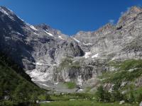
I unfortunately don't have photos of the approach from the south. There are 2 different 'gaps', each marked with its own sizeable cairn. The eastern one being a bit larger than the one to the west if my memory serves me correctly. If you have the coordinates it is almost impossible to miss (hence the lack of photos on the thread I think...).The 2 gaps are about 150m from each other with their own routes down. See image below.
We did the eastern one for the 1st time during our S-N GT in December of last year and found it a little easier than the western one. The route down for both is quite obvious if you're at the right spot at the top and is really not that big a deal. I would however advise to use the western one when wet.
Here are the coordinates for the 2 gaps:
East: S29° 18.289' E29° 26.174'
West: S29° 18.232' E29° 26.113'
Happy to share the 2 gpx tracks if you're interested. Feel free to PM me if needed.
Please login or register to view the image attached to this post.
Last edit: 07 Apr 2026 17:32 by supertramp.
The following user(s) said Thank You: petroengel
Please Log in or Create an account to join the conversation.
- supertramp
-
- Offline
- Elite Member
-

Less
More
- Posts: 225
- Thank you received: 455
08 Apr 2026 09:48 - 08 Apr 2026 09:48 #80311
by Riaang
Replied by Riaang on topic Late departure time from Giants Castle Reserve
Hi Petroengel
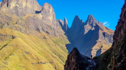
The gap is between two rocky outcrops with the one on the left higher than the one on the right. Quite distinctive if you come from below.
The gap is between two rocky outcrops with the one on the left higher than the one on the right. Quite distinctive if you come from below.
Please login or register to view the image attached to this post.
Last edit: 08 Apr 2026 09:48 by Riaang.
The following user(s) said Thank You: petroengel
Please Log in or Create an account to join the conversation.
08 Apr 2026 09:52 #80312
by Riaang
Replied by Riaang on topic Late departure time from Giants Castle Reserve
The spot is about 483m from the escarpment according to Google Earth.
However, there is a far easier way I've been using for many years to get over Durnford ridge. If you go more towards the left (i.e. inland, away from the escarpment edge) there are 3 broad grassy sections you can use to go over the ridge. Much easier and safer, especially in snow!
I have a track for the normal Durnford Gap if you want it, but I should also have one for the grassy section we used last time. I'll see if I have a pic and track for these and will post if yes.
The following user(s) said Thank You: petroengel
Please Log in or Create an account to join the conversation.
08 Apr 2026 10:02 #80313
by Riaang
Replied by Riaang on topic Late departure time from Giants Castle Reserve
Ok, so here are the grassy ledges. There's 3 I've tried, see pic below.
If you look at my track I use a different route on the northern side of Durnford ridge. I find it shorter and easier than the typical route down the vallley and then gradually up to the gap. Since the grassy ledge is a bit more inland, this is sort of the natural route to follow, you'll clearly see the lie of the land will sort of make you take this route automatically - unless you want to walk further via the normal gap route
If you look at my track I use a different route on the northern side of Durnford ridge. I find it shorter and easier than the typical route down the vallley and then gradually up to the gap. Since the grassy ledge is a bit more inland, this is sort of the natural route to follow, you'll clearly see the lie of the land will sort of make you take this route automatically - unless you want to walk further via the normal gap route
Please login or register to view the image attached to this post.
The following user(s) said Thank You: petroengel
Please Log in or Create an account to join the conversation.
08 Apr 2026 10:27 #80314
by Riaang
Replied by Riaang on topic Late departure time from Giants Castle Reserve
Ok, herewith lots of data on Durnford.
To the left (this is the view from the NW, from near Bannermans cave. Coming from the South you wouldn't see this, but you would know where to go and what to expect based on this pic) is Durnford Gap. To the right are the grassy gullies. There's more than 3 actually, but depending on how we feel or where we find ourselves, we use the one closest to us.
The red line is how hikers typically walk to go through Durnford Gap. The green line is the one we normally follow. More direct, shorter. Yes, a bit steeper initially, but once you get close to the ridge you basically mainly traverese till you get to the grassy gullies.
When we went over Durnford in Aug 2021 there was a lot of snow and ice and we couldn't use Durnford gap. Way too steep with the risk of sliding down very high. The grassy gullies wer emore gentle and deeply covered in snow, so we sort of walked/slid down them but they were safe and it was actually a lot of fun. Even in the wet these gullies are safer.
Please login or register to view the image attached to this post.
The following user(s) said Thank You: Sabine, petroengel
Please Log in or Create an account to join the conversation.
08 Apr 2026 10:38 #80316
by Riaang
Replied by Riaang on topic Late departure time from Giants Castle Reserve
A bit more zoomed in picture. I also have the gps track for the last time we went over via one of the grassy ledges (pm me with your email address if you want it, or both).
Please login or register to view the image attached to this post.
The following user(s) said Thank You: petroengel
Please Log in or Create an account to join the conversation.
08 Apr 2026 11:05 - 08 Apr 2026 11:11 #80319
by Riaang
Replied by Riaang on topic Late departure time from Giants Castle Reserve
Below a couple of pics of what the terrain looks like when you take the green route towards the grassy gullies described above. Quick description for the approach from the North, just do the reverse for coming from the south.
Way down on the valley floor you start at the same point. For the approach via Durnford gap you would typically go out to the eft, but in our case simpluy walk straight up the valley towards Durnford. I normally find water here quite high up, even in winter. At one point you will sort of realise you now need to turn left as you will walk into the rockbands if you continiue going straight up. You will still be skirting the little triangle hill on your left, with Durnford on your right now. Keep going till you get to the little neck /col between the triangle koppie on your left and Durnford on your right. Close to this saddle you will find a very squire edged rock, quite distinctive, on your left. Pass it and very shortly afterward you will be on the saddle. From the previous photos it might look like the lower rock bands are impassable, which is probably why poeple initially went around to Durnford gap, but as you pass the saddle you can basically immediately start going up higher, as you will see from the photos below it's a bit rocky at the one section but no steep rock walls to try and go over. You will see 3 grassy gullies above you (if it's not misty!!!!!!!), just pick one and go over Durnford ridge. No issues on the other side either, or simply walk left to meet up with the Durnford Gap descent point.
Looking back to the valley and Bannermans ridge where we started from. See the square rock near the bottom and middle of the pic?
Once through the saddle and after turning left and climbing higher, here's your view on the grassy gully
Please login or register to view the images attached to this post.
Last edit: 08 Apr 2026 11:11 by Riaang.
The following user(s) said Thank You: petroengel, Wandelaar
Please Log in or Create an account to join the conversation.
